Minnesota Hunting & Fishing Intelligence
Track Minnesota lakes, deer permit areas and stocking events — for the trips you actually take this season.
15,000+ lakes across the Upper Midwest. 133 Minnesota deer permit areas. 15 active government data pipelines. Built for hunters and anglers who pay attention to the details.
By the numbers
The data layer behind every trip.
Lakes & Waters
15,000+
lakes mapped
1,000+
AIS-monitored waters
13,000+
stocking events tracked
Hunting Intelligence
133
deer permit areas with CWD risk scoring
3-year
rolling sample window per zone
Data Foundation
97
verified government data sources
5
state wildlife agencies, refreshed on published cadence
Stay ahead
Get MN stocking reports and spawn alerts.
We send intel when something actually happens — a new walleye plant, a spawn window opening, a CWD band change. Not a newsletter cadence.
Free. No spam. Unsubscribe with one click.
Public Health Surveillance
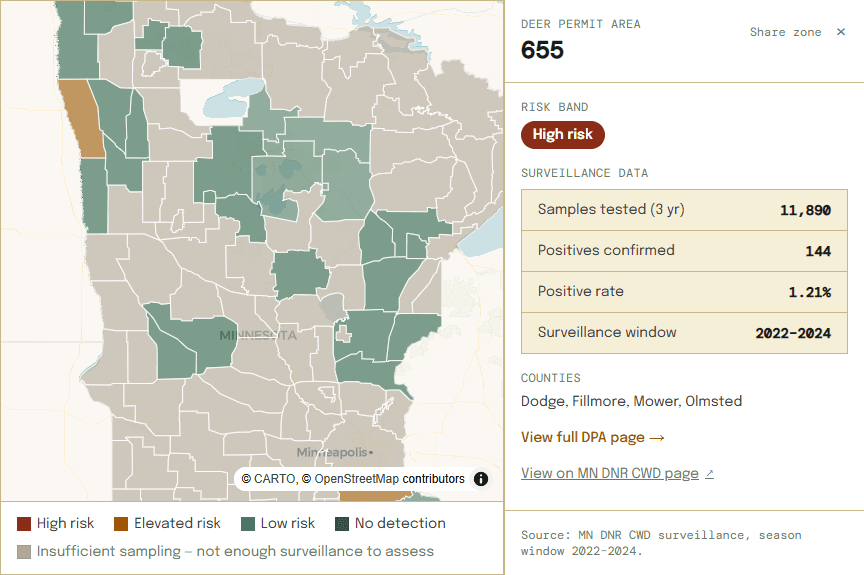
Where CWD has been detected in Minnesota deer permit areas.
All 133 Minnesota deer permit areas mapped against a rolling 3-year window of MN DNR surveillance data. Where sampling is too thin to assess a rate, we say so rather than guess. Click any DPA for confirmed positive counts, sample sizes, and county coverage. Free for anyone, always.
Explore the full MN CWD map →Data from MN DNR CWD Surveillance Program · Updated as new totals publish
Aquatic Invasive Species
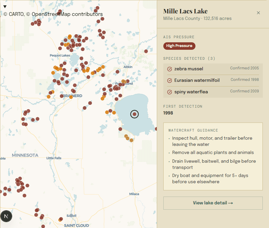
Where AIS has been confirmed in Minnesota lakes.
Minnesota lakes in the MN DNR monitoring footprint — confirmed detections, county-suspected status, and watercraft guidance. Free for anyone, always.
Explore the full MN AIS map →Data from MN DNR AIS monitoring program · 1,013 lakes tracked
Membership
One tier does almost everything.
Field
Know when, where, and whether.
Less than half a MN fishing license
- Everything in Scout
- Walleye spawn window analysis for Minnesota lakes — refreshed each spring season
- AIS presence data for monitored Minnesota lakes — MN DNR infested-waters list
- Stocking history and trend analysis per lake — updated weekly
- Waterfowl habitat quality score for 22,000+ Minnesota lakes
- Deep-dive lake analysis tab
- Unlimited saved lakes and DPAs
Scout (free, lake search + 3 saved entities) and Outfitter (pro tools, multi-state) also available.
Government data, mapped
This week in Minnesota.
Field users get personalized alerts for their saved lakes and DPAs. Anonymous visitors see statewide activity.
See all MN intel →Check before you go.
Free Scout account takes 60 seconds. No credit card. Start tracking your lakes and deer permit areas today.
Create free Scout accountData sourced from 15 active government data pipelines including the Minnesota DNR Fish Stocking Database, MN DNR CWD Surveillance Program, USGS National Hydrography Dataset, EPA AIS records, USFWS National Wetlands Inventory, USDA NLCD, USDA NRCS CRP data, NOAA Daymet climate data, and MPCA water quality records. Stocking data updated weekly · AIS records updated seasonally · Spawn predictions use Daymet GDD accumulation (1980–2023) · CWD surveillance window: rolling 3-year aggregate.